Current TransFagarasan road status: Open, with restrictions.
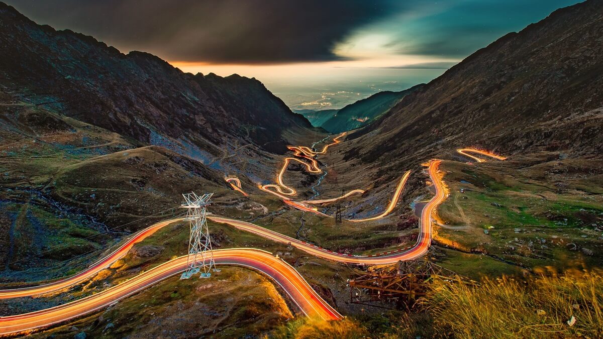
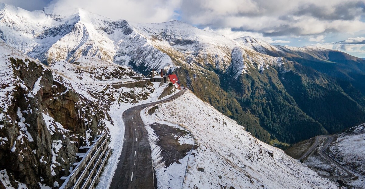
Also labeled "the Road to the Sky", "the Road to the Clouds", "the Best Driving Road in the World" and even "A spectacular Monument to Earth-Moving Megalomania" the TransFagarasan climbs, twists and descends right through Moldoveanu and Negoiu - the highest peaks in Fagaras Mountains and in Romania. This is no pass through a gap but a frontal assault, a stark and spectacular reminder of unchecked power stamping itself on an obstreperous landscape.
Built for military purposes - at the initiative of Romania's last communist leader Nicolae Ceausescu - this dynamite-forged road connects two of Romania's historic provinces Transylvania (the Center) and Walachia (the South) through a series of five tunnels, 27 viaducts and 831 small bridges.
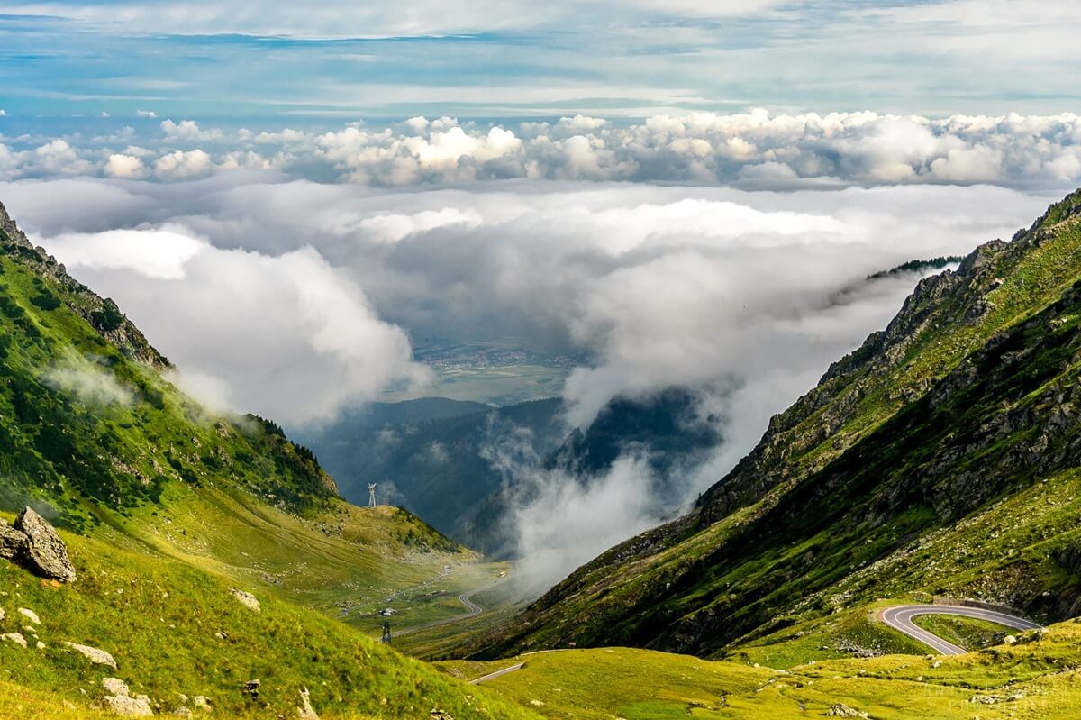
The TransFagarasan ranges in elevation from 1,630 feet at Cartisoara to almost 6,700 feet at Balea Lac.
The road is below the tree line until about 5,000 ft. and then it opens up and reveals itself.
No visitor should not get discouraged by the significant elevation difference;
the road is a relatively easy climb even for bicyclists weighted down with all necessary equipment.
Because it was engineered to be accessible to heavy military vehicles
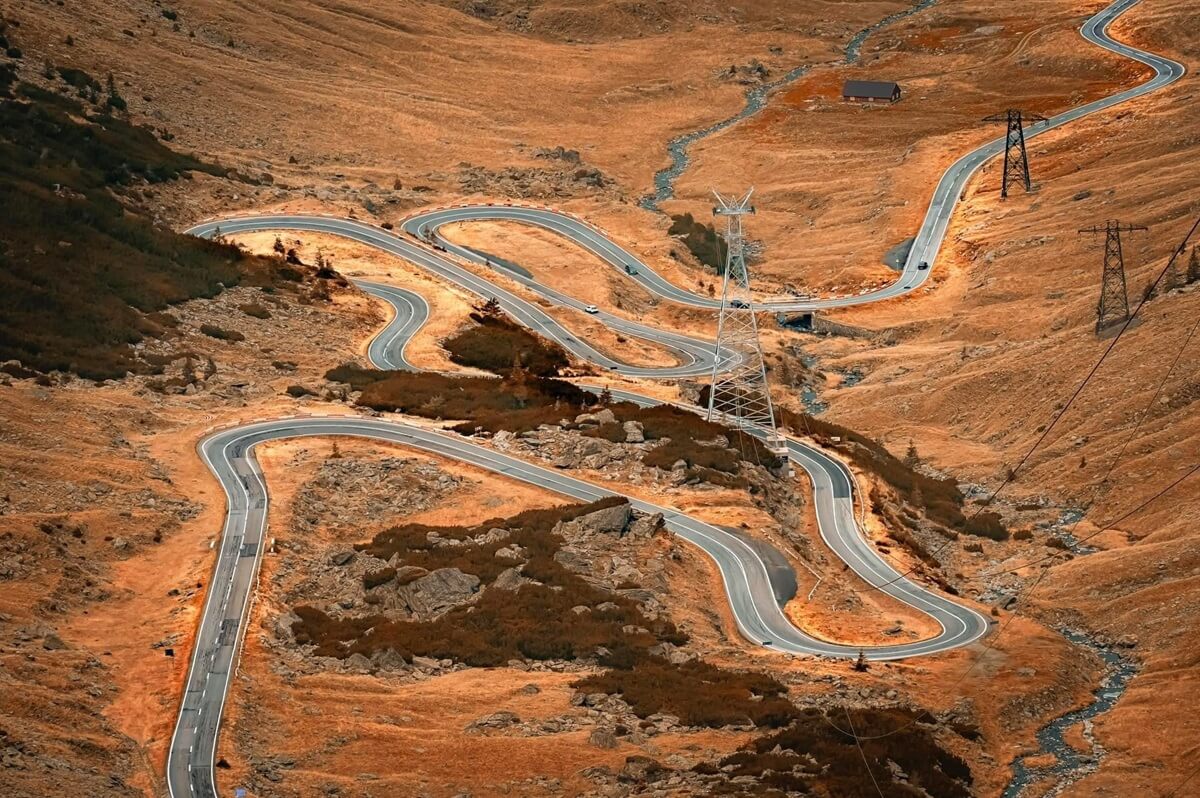
the Transfagarasa's gradient is never too steep, hence the many hairpin bends or switchbacks.
During off-season and weekdays, the Transfagarasan is still relatively unperturbed by the motoring masses.
However, this scenic road can get quite crowded during vacation months (July and August) and weekends.
...
TransFăgărășan Facts:
Begins: Curtea de Argeș (95 miles NW of Bucharest)
Ends: Carțișoara (30 miles east of Sibiu)
Distance: 71 miles (114 kilometers).
Route time: 3 hours, without stops. A leisurely drive can take all day.
Road condition: paved, good.
Highest point: 6.699 ft (2042 m) - Lake Bâlea
# of tunnels: 5
TransFăgărășan tunnels dimensions:
Width (d1): 6 m (19.5 ft.) to 7.2 m (23.5 ft.)
and
Height (d2): 3.9 m (12.8 ft.) to 4.2 m (14 ft.)
Visitor Video .
Gateway cities:
Sibiu (30 miles W) and Brașov (65 miles E) of Carțișoara,
Pitești (23 miles S) and Bucharest (96 miles S) of Curtea de Argeș
...
TransFagarasan winter time closure
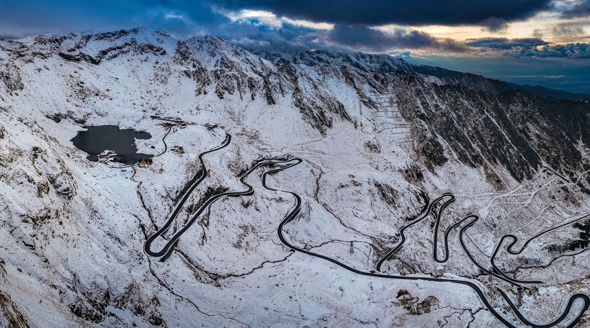
Open end-to-end: July 1 through October 31 (weather permitting).
The road is usually closed from November until July.
Early re-opening happens when weather is good,
all snow has been removed from the road and there is no danger of avalanches.
Romania's Road Authority ususally announces the early re-opening 24 to 48 hours in advance.
TransFagarasan scenic road re-opening / closing dates:
| Year | Re-Opening date | Closing date |
|---|---|---|
| 2026* | June 12 | tentative date: November 1* |
| 2025 | June 6 | October 5 |
| 2024 | June 7 | November 12 |
| 2023 | June 21 | November 6 |
| 2022 | June 15 | November 17 |
| 2021 | June 28 | October 25 |
| 2020 | July 1 | October 20 |
| 2019 | June 29 | November 4 |
| 2018 | July 1 | November 11 |
| 2017 | June 16 | November 1 |
| 2016 | June 18 | November 1 |
| 2015 | June 27 | November 2 |
| 2014 | July 1 | November 1 |
...
...
Points of note:
Curtea de Argeș Cathedral
Manastirea Curtea de Arges
Commissioned in 1514 by prince Neagoe Basarab, Monastery Curtea de Arges
is a fine example of Byzantine Orthodox church architecture.
It was completed in 1517 and dedicated to the Assumption of the Virgin Mary.
In the second half of the 19th century, the monastery went through major restorations,
under the supervision of architects Andrei Lecomte du Nouy (French) and Nicolae Gabrielescu (Romanian).
Moorish arabesques decorate the exterior while the interior features
outstanding frescoes by painters
Emile-Frédéric Nicolle,
Charles Paul Renouard (French) and Nicolae Constantinescu (Romanian).
The Great Saturday Resurrection Gospel, written in gold letters by Queen Elisabeta of Romania,
is on display in the monastery.
Curtea de Arges Train Terminal
Gara Regala Curtea de Arges
Built after plans by French architect Andre Lecomte de Nouy,
Curtea de Argeș train terminal is beautiful Neo-Romanian style structure
adorned with enameled ceramic and fish scale roof tiles, brought from Italy.
A Paul Garnier* clock, manufactured in late 1800s,
can still be seen on the side of the building facing the rail tracks.
*(Paul Garnier, was a 19th-century French watchmaker and mechanic.)
Vlad the Impaler (Dracula) Fortress
Cetatea Poienari - village Arefu
The Carpathian Mountains refuge of Prince Vlad Tepes - Draculea, the historical figure
who inspired the novel Dracula.
Vidraru Hydroelectric Dam / Reservoir
largest (concrete) arch dam in Romania
| Vidraru Hydroelectric Dam facts: | |
| Year built: | 1965 |
| Height: | 545 ft. |
| Cubic-feet of rock excavated | 63.6 million |
| Cubic-feet of concrete poured into the dam structure | 32.9 million |
| Length of underground galleries | 26 miles |
Lake Vidraru Reservoir: | |
| Area: | 2,210 acres |
| Length: | 8.8 miles |
| Width: | 1.4 miles |
| Circumference: | 18 miles |
| Deepest point: | 509 ft. |
| Water stored volume: | 1.65 billion cubic-feet |
| Elevation: | 2,724 ft. above sea level |
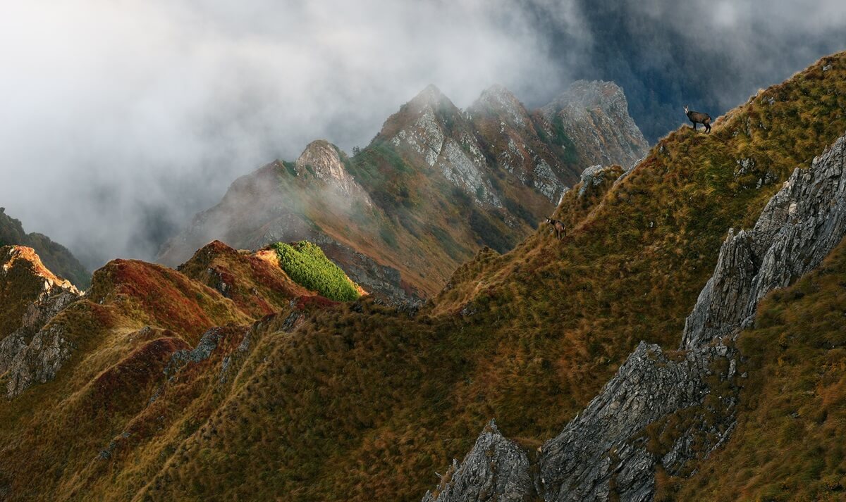
Also known as the "Transylvanian Alps",
the Fagaras Mountains are rich in unique wildlife and scenic hiking and biking trails.
Golul Alpin - a varied relief nature reserve
with rocky cliffs, glacial lakes, hanging valleys, moraines, sloping peaks, valleys, springs, pastures, and forested areas,
rich in wildlife.
Balea waterfall (Bâlea Cascadă)
TransFagarasan road video:
Other Carpathian Mountains Scenic Drives:
TransAlpina,
TransBucegi